PRELIMINARY REPORT
UNDERGROUND NOISE
at
SINKS CANYON STATE PARK
LANDER, WYOMING
Kevin T. Kilty
CHEYENNE, WYOMING
May 31, 1992
Introduction
Water flowing at the air interface in caverns and channels, water dripping from cave ceilings, and objects being moved by water on cave floors all provide sound which propagates through the ground and which may help map the course of the cavern itself. Early research in acoustic mapping of karst was done by Arandelovic (1969), Lange (1971), who tested noise amplitude measurement as a mapping method, and Lange (1972), who suggested locating discrete cave noises as a mapping method.
Noise amplitude as a measure of proximity of a cavern is deficient in several respects.
First, it is distorted by local geology and the vagaries of planting geophones. The maximum noise amplitude may not occur immediately above a cave.
Second, noise is contributed by a variety of natural and cultural sources. A pure amplitude measure cannot distinguish between these and cave sounds.
Mapping discrete disturbances avoids most of these problems, but presents a few of its own. First, do discrete events occur often enough to map a cave in reasonable time? Second, can discrete events be timed accurately enough to make a useful map? Remember in the context of this second question that the time origin of the event is not known the way it is in traditional seismic exploration work.
There is no reason to believe that noise from water flow in caves has only amplitude as a distinctive characteristic (white noise). In fact if one puts on headphones and listens to water noise in karst as it sounds on the ground surface, he notices rumbling sounds and occasional plunks and scrapes. The nature of a cave itself and the mechanisms that produce cave noise lead one to believe that the noise spectrum is probably quite colored. If the character of this noise can be identified it might provide means of overcoming the deficiencies of pure amplitude measures. Moreover, if the color of the noise spectrum is largely the result of cave geometry, then it may provide a means of mapping caves in dry regions where no water flows though the cave, and sound must be supplied by a noise source (a starting pistol, for example).
Objectives
My long term objective of this research is to develop methods of mapping Karst channels and caverns from the ground surface. The objective of the present project is simply to provide information about the nature of sound produced by water flowing through karst and to determine what type of equipment is required to make the necessary measurements. In addition I need to test my field equipment, much of which is custom built and the rest of which was never designed for field operation.
Equipment
Transducers for the survey include two Hall-Sears L4C seismometers with a resonant frequency of 1Hz. These geophones have a large electrodynamic constant of about 5V/in/sec, and provide better signal for underground listening than do standard seismic phones (Litton Mark IV for example), even though seismic phones are available with good response above 100Hz.
The geophone signal is feed into an instrumentation amplifier with very flat response over a wide range of frequency (Dc to 300Khz). The amplifier has an adjustable gain of 3,10,30,or 100 and amplifies the voltage difference between the two leads of the geophone. Any common mode picked up by the leads is rejected at a ratio of about 10,000:1.
Output from the amplifier is fed to a portable spectrum analyzer. This device is based on a single board instrument built by SpectraMax, Inc. of Boulder, Colorado*, which is mounted in a cradle under a Toshiba laptop computer. The spectrum analyzer provides the sampling, signal processing, and spectrum calculation, while the laptop provides the user interface, control, and display. This equipment is designed to be run for a short length of time from an internal battery or from an AC power source.
I designed and constructed a 24-Volt battery power supply to power my field equipment. This supply is based on two 26 amp-hour lead-acid cells which are discharged in series to give 24V, but charged in parallel.
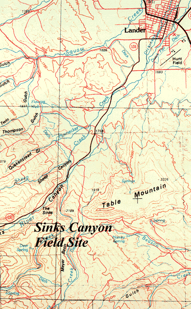
Figure 1. MAp of Sinks Canyon relative to Lander, Wyoming.
Field Survey
I conducted a brief survey at Sinks Canyon State Park on Thursday and Friday May 14th and 15th, 1992. Problems I encountered included: (1) A battery power supply that was far heavier than needed and a burden to carry in the field. I am building a new power supply of 8 amp-hour capacity which is 1/3 the weight of the present supply and which will power the field equipment for 7 hours. (2) An instrumentation amplifier that popped fuses and was completely unusable. (3) Signal level from the Hall-Sears seismometers that was too low ( approx. 1-2mV) to be recorded by the spectrum analyzer directly.
Problem 1 was no more than a nuisance. Problems 2 and 3, on the other hand, were detrimental to this particular field effort. An inexpensive radio receiver I purchased at Radio Shack and modified to act as a preamplifier provided suitable signal level to record at a station near the sinks themselves, thus providing us with some information. Unfortunately, this receiver does not have the flat response of the instrumentation amplifier. The response of this amplifier reaches a maximum at mid frequencies, 100Hz to 1kHz. I undoubtedly need to adjust my results because of amplifier response.
Gain of this receiver was about 6-7, which is much less than the instrumentation amplifier. In order to achieve more gain I wired the two geophones in series. This has the effect of reducing any sounds that have a coherent phase difference at the two phones.
The spectrum analyzer was allowed to run in free mode for several minutes at each site acquiring 20 separate samples of ground noise and calculating an average. Each sample of ground noise was 2 seconds long and was smoothed with a Hamming window before calculating the spectrum.
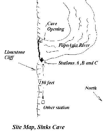
Figure 2. Immediate area of the Sinks and geophone locations.
Results
Only one field location provided enough amplitude from the geophones to measure on the analyzer only at the sinks themselves. Location of this site and another site at which I made a direct aural measure of cave noise are shown in Figure 1. The spectra are shown in figures 2 and 3. The difference between the two spectra is only in the placement of the two geophones relative to one another and to the sinks.
In Figure 2 the spectra came from two geophones wired in series and placed side-by-side on hard rock at the sinks. In Figure 3 the geophones were separated by 1 meter parallel to the cliff face. Separating them by 1 meter perpendicular to the cliff face made virtually no difference in the spectra. All spectra are very similar the only difference being that Figure 2 shows peaks at 36Hz, 85Hz, and 110Hz that are narrower and larger. This might result from one of the geophones ringing against the other when the two are placed side-by-side. The similarity of the spectra demonstrate that the signal is relatively independent of geophone plant.
All three spectra are characterized by the following features.
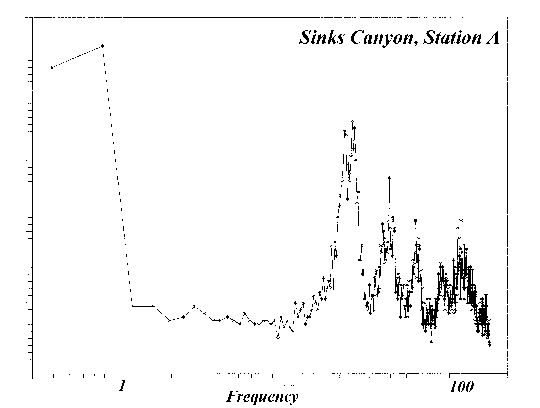
Figure 3. Spectrum as recorded at site A.
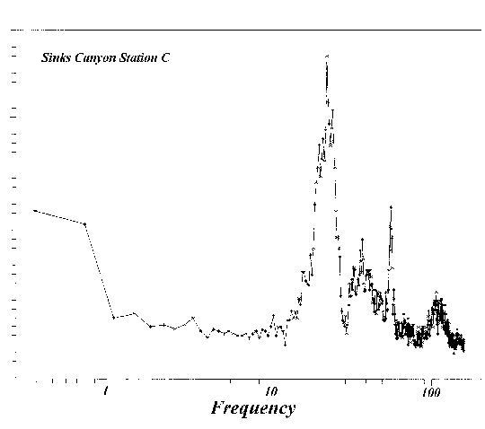
Figure 4. Spectrum as recorded at site C.
Direct listening
By plugging headphones into the amplifier output I could listen directly to the underground noise. At the sinks themselves the sound was very distinct, and 100ft away from the sinks the sound was essentially the same. It was much subdued at this distance and couldn't be recorded by the spectrum analyzer. While the output of the geophones had to be above 1mV to be recorded by the spectrum analyzer, a signal of only a few tens of microvolts is probably detectable by ear in a headset. The sound is best described as combination whir and grind, like a running motor (an electrical motor) or like a metal cylinder rolling across a hard surface, or like pebbles flowing into a large tank. A spectrum composed of distinct peaks probably sounds much like this. Thus, it seems reasonable that the sounds being heard in the geophones are essentially those recorded by the spectrum analyzer and displayed in Figures 2 and 3.
Concluding remarks
My field survey established that it is possible to record ground noise spectra directly in the field, and that the spectra from flow into a cavern displays distinctive features. The spectra appear to be composed of a few broad peaks superimposed on a 1/f noise background. Whether or not the spectra can be recorded any distance away from the cave opening, or whether the information can be used to map the cavern is the subject of further research.
References and Notes
Anandelovic, D. (1969) A possible way of tracing groundwater flows in karst. Geophysical prospecting 17 (4): 404-418.
Lange, A.L. (1971) Acoustic tracking of karst streams. Caves and Karst 12 (3): 20-24.
Lange, A.L. (1972) Mapping underground streams zusing discrete natural noise signals: a proposed method. Caves and Karst 14 (6): 41-44.
SpectraMax, Inc. 1530 55th St., Suite 127, Boulder, CO 80401 (303) 444-7479. Note that this company is no longer in business.