In what follows I will summarize four possible sources of rotation in clouds. A rotating thundercloud appears to be a prerequisite to form a tornado.
As the earth turns on its axis each day, the air it carries with it also turns. Thus, air that is stationary with respect to the earth's surface actually spins with respect to the fixed stars (as they say). It makes one complete turn in a day. This vorticity is called planetary vorticity. If a broad shallow layer of air were to flow into a tall thin column for a long time, and rise upward near the center of the column, the planetary vorticty would flow with it and become concentrated near the center of the thin layer. This is how a hurricane, or an extratropical cyclone acquires its spin. In the northern hemisphere a large parcel of air that is at rest on the earths surface is actually spinning counterclockwise in space (looking down from above the north pole). Thus, stationary air masses have cyclonic spin in the northern hemisphere.
The problem with this source of rotation is that it takes so long to develop. Only very long lived thunderstorms, those that last for 4 hours or longer, can develop intense rotation in this manner. It is even more difficult to use this source to explain rotation in a tornado.
The Rossby number is a measure of the tendency of planetary vorticity to contribute to storm rotation. Of course we do not fully understand the source of tornado rotation, so maybe it is presumptuous to calculate a Rossby number based on a characteristic length and time. However, if one assumes characteristic lengths of a few kilometers (at most) and time scales of minutes to perhaps half-an-hour, the resulting Rossby number suggests this is an insignificant contribution.
Rossby Number Ro=V/2WL where;
V = A characteristic velocity
W = Angular rate of the earth times sine of latitude.
L = A characteristic length
Let's examine an example. The inflow to a tornado is very brisk only very close to the tornado. Retreat a distance of a kilometer or more and the inflow may be only a few meters per second. So let V=10m/sec or less, L=1000m, and W=0.0005 at 45N latitude. Then the Rossby number is about 10, or, in other words, the characteristic inflow to a tornado-like vortex is characteristically 10 times "faster" than the turning of the earth. The turning of the earth plays only a minor role for such a flow. The larger the Rossby number, the less important is the turning of the earth.
Within a synoptic low pressure system air flows in a counterclockwise fashion in the northern hemisphere. Therefore, as long as tornadoes and the thunderstorms that spawn them develop within synoptic low pressure systems, they have at their disposal a large mass of surrounding air with positive vorticity. If a large, shallow mass of this air were to draw toward a central location and then rise, it would concentrate the positive vorticity near the center of flow. In this way a local thunderstorm can concentrate the general cyclonic vorticity of the synoptic system. You can imagine an entire spectrum of flow systems in this sense. First, a synoptic low pressure system concentrates positive vorticity through a general convergence of air near the surface. Thunderstorms further concentrate this vorticity through convergence into their updrafts. The thunderstrowms rotate. By some as yet unknown mechanism there is a further convergence of the rotating air in, and near, a thunderstorm which further concentrates vorticity into a tornado. Finally, within the rotation of a tornado a final convergence of air concentrates vorticity into suction spots. The obvious prototype of such a cascade is the hurricane, which often spawns tornadoes. And, the process is like Richardson's parody of Swift's poem.
Greater whirls have lesser whirls
that feed on their velocity
and lesser whirls have smaller whirls
and so on to viscosity
Click on this anchor to have a look at the result of concentrated planetary vorticity in a Powerful Synoptic Cyclone in the northeast Pacific in December, 1995.
A cold front separates cool air to its north/northwest from warm air to its south/southeast. A dry line simply substitutes dry air for cold air, and otherwise behaves the same. There is vertical wind-shear along these lines or fronts. The wind within the cold (dry) air typically blows toward the east and south; while wind within the warm air blows to the north and northeast or even northwest. The boundary between these flow regimes is called a wind-shift line. An imaginary rotor placed on the wind shift line with its axis vertical would turn counter clockwise. Thus, the wind shift line is a source of cyclonic vorticity. The vorticity here is derived from concentrating planetary vorticity, and thunderclouds that develop along a wind shift line will find it easier to develop rotation from this concentrated source, than directly from the more diluted planetary source. In effect the thunder head draws in a broad shallow pool of vertical vorticity and stretches it vertically. This amplifies the vorticity producing rotation of the cloud.
A miniature cold front and wind shift line develops on the flank of a thunderstorm. Entire families of landspouts may develop along this line. I have included a photograph that shows 2 such landspouts among a family of 4 or more that occured west of cheyenne in July 1973. Because vorticity already extends from cloud to ground along the windshift line, it provides an explanation for the speed with which a tornado can connect cloud to ground, and why they can appear to form any place in between.
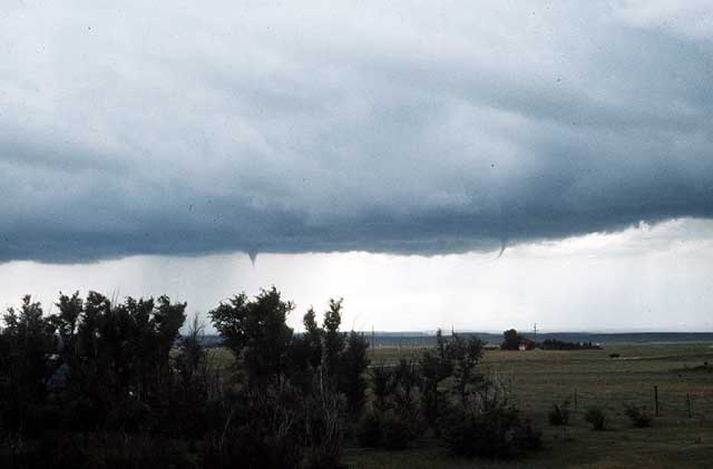 Several landspouts along a windshift line.
The boundary layer is a source of wind shear and horizontal vorticity. Thus, picking up horizontally directed vorticity and turning it into a vertical direction provides a source of cyclonic spin. Maxworthy seems to be the first person to propose this as a source of rotation in dust devils, water souts, and tornadoes; although other people probably recognized it before him. Because there is friction between the air and ground surface, wind speed decreases to near zero at the ground surface. The wind above is free to blow, and in the northern hemisphere, midlatitudes this wind typically blows from west to east. Therefore, an imaginary rotor held near the ground surface, with its axis oriented to the north will turn in a clockwise fashion; and this boundary layer near the ground contains concentrated vorticity.
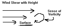
Vertical wind shear at the ground surface produces vorticity with the threads lying horizontally.
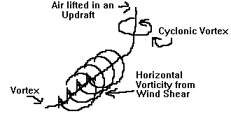
Lift a thread in an updraft and the horizontal vortex thread becomes vertical.
Nearly all of this horizontal vorticity is within 10m of the ground surface, and, as Maxworthy points out, probably is actually within a meter. Thus, it makes a very plausible source of rotation for a dust devil. Figure 2 shows that if a parcel of this vorticity is lifted by buoyancy, then the horizontal vorticity is converted into vertical vorticity. The vorticity equation for inviscid fluid shows that a vertical shear (dw/dx<>0) will tilt the horizontal vortex line into the vertical direction; and accelerating uplift (dw/dz<>0) will stretch vertical vortex lines and amplify them.
Unfortunately, just lifting a parcel will tilt both cyclonic and anicyclonic vorticity leading to no net vertical rotation of the parcel. However an uplift that manages to move to the right in such a wind shear will prefer to lift and accelerate cyclonic vorticity. This leads to an intense, vertical cyclonic rotation. vortex lines leave the top of the rotation to return to the ground surface again behind and to its left. Maxworthy states that this leaves a wake in the wind shear behind a dust devil and prevents the anticyclonic swirl from affecting the motion of the dust devil. However, I believe the anticyclonic vortex lines returning to the ground surface actually modify the wind shear in such a way that pushes the suction end of the dust-devil to the right. Thus, the dust devil is maintained for long periods of time as long as it has a wind shear to feed upon.
When we attempt to apply this source to rotate a thundercloud, we find the thinness of the boundary layer is a problem. It is easier to envisage boundary layer vorticity as a source for a tornado. An interesting question to ask in regard to this model is, do tornadoes become more intense just as they reach the ground surface?
I do not know if the community of tornado research knows of J.R. Eagleman and his co-workers at the University of Kansas. They proposed a theory of tornado genesis (Thunderstorms, Tornadoes, and Damage to Buildings, Res. Rep. HEW Contract no. EC0030, UofKansas, 1970, 253p.) in which the plume of a growing thunderstorm generates the vorticity through an interaction with the ambient winds. In their view the plume develops a dipole flow, which allows the thunderstorm to act as a solid cylinder in the ambient winds. Outside the thunderstorm column the ambient wind field parts and flows around the thunderstorm. Within the thunderstorm there develops two, counter-rotating vortexes that encourage both the slip-stream of environmental winds, and stability of the growing thunderstorm. The figure below is a plan-view of a thunderstorm from above in their model.
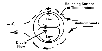
The figure shows a cylindrical bounding surface of the thunderstorm. Ambient winds approach it and flow around it in a slip-stream. There is a stagnation point both upstream and downstream of the thunderstorm. Inside the cylinder is a dipole flow field which results in two vortexes (vortices for you purists) each of which is a low pressure center. We will discuss more of this model in the next section.
Project suggestion: Does the surface pressure beneath a thunderstorm square with this theory? How long might it take to develop the dipole flow within the thunderstorm?